Grade 1 is Easy to Moderate.
You’ll be walking mainly on good paths, at low altitude with occasional accents and descents.
Grade 2 is Moderate to Challenging
Combining both moderate grade walking with some strenuous hiking. Ideal for those who are fit, active and want a demanding day-hike.
Grade 3 is Challenging to Difficult
You need to have a good level of fitness and trekking experience is recommended. Trekking days are generally long; terrain may be difficult with often demanding ascents and descents.
Turnaround Point
On our longer hiking days, there will usually be a shorter hiking option. You will find the distance and approximate timing at this symbol.
All trekking descriptions are for ONE WAY
All trails return in the same direction
Trail Time indicates distance and timing for the RETURN journey
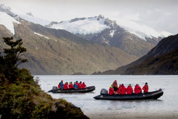
For all our holidays in Patagonia please click the following links
GET READY FOR TRACKING IN PATAGONIA
PACKING LIST FOR TRACKING IN PATAGONIA
Villarrica National Park - Pucon, Chile
Los Crateres - Included
- Grade 1
- 8km
- 5 miles
- 3.5 hours (return)

Hiking in Pucon national park, Chile
Heading first across an old lahar, the trail then has a short steep section as it enters the thick forest. While hiking through this section you are shaded from the direct sunshine and have 3 short passes as you undulate through the forest. The trail continues to climb as the forest gets lower and eventually, you arrive at a small terraced lookout point signed “Mirador”. From this point you have a beautiful view towards the Villarrica Volcano, the green covered mountains back towards the Argentina border and the enormous Lake Villarrica of which the town of Pucon is nestled right next to.
Viewpoint - 6km/3.7mi ( return distance)
Continuing the trail descends towards the volcano. Soon you will find the first signs of lava from a recent eruption. The trail follows the lava flows uphill. Arriving at the second lookout you’ll find craters about 5 to 10 meters wide. The lava formed interesting folds, in some parts they have given way and you are able to see several meters into deep caverns.
Climbing Villarrica Volcano - Optional
- Grade 3
- 4-5 hr (ascent)
- 3-4 hrs (descent)

Climbing Villarrica Volcano, Chile
The availability of this activity is dependent on weather conditions
When heightened levels of volcanic activity occur this optional hike is not available
This is a challenging trek on the slopes of the active Villarrica volcano (2847m/9340ft). You will need to have a high level of fitness to complete this ascent. A portion of this trek will be done in crampons and possibly with the assistance of an ice axe, (they will be provided by the company but you must carry them in your pack). You will have an elevation gain of between 1000-1600m
With an early start, you will drive approx. 40 minutes to the base of the volcano. At this point, you may have the option to skip the first 600m ascent and catch the chairlift up instead (this option is not always available and is at an additional cost). You will hike in 45-minute bursts with short rest breaks until the snow line. At this point, you will use your crampons, an ice ax and hike in single file. As you get closer to the summit and on a clear day your view of the surrounding area will extend to see eight other volcanoes as well as Villarrica lake and Pucon town. Once you are at the summit the time allowed at this point will depend solely on weather conditions with a maximum time of 45 minutes.
After all that hard work it’s time for a little fun! You will slide down the snow section on a small plastic seat using your ice axe for a break. The rest of the descent will be on foot with transport waiting for you at the bottom.
IMPORTANT: The guides set a comfortable pace which allows for short rest stops, photos and they have you arrive at the top with time to enjoy your achievement. However, if you are unable to maintain this comfortable pace for the duration of the activity you may be asked to turn around and not allowed to continue. This is for health and safety reasons and would be explained in detail if it would occur.
Huerquehue National Park - Pucon, Chile
Small Circuit - A Los Lagos - Optional
- Grade 2
- 16 km
- 7.5 miles
- 6 hrs (return)

Hiking in Pucon national park, Chile
The first section 2.5km/2mi is considered easy and has a wonderful trail near the lake
The second section of this hike has a steep accent / decent section
From the entrance of the national park, you take Trail Nirrico, delving into the forest that runs almost right next to the lake for a kilometre. You pop out of the forest and cross several private properties that are located at the end of the lake. Here starts the trail marked “A los Lagos” (to the lakes). The path climbs an old timber trail along the mountain slopes through a forest with a lot of bamboo. After approx. 40 minutes along a steep trail you will arrive at a checkpoint hut has toilets and potable water.
Continuing along the steep trail there are 2 waterfall detours (Nido de Aguila and Trufulco) as well as 2 viewpoints where you can see Lake Tinquilco and the Villarrica Volcano in the distance. As you head over the wooden bridge and towards Lake Chico you see the first araucarias (monkey puzzle trees) aged 500 to 1000 years old.
At this point there is a split in the trail; heading right for a short distance to arrive at Lake Toro with a beautiful view of the mountains behind the lake. Return back to the split and head left, this takes you towards Lake Verde where there is a great spot for a picnic lunch. Depending on your speed, timing and enthusiasm you can continue a little further along the lake to the shoreline or you can turn around at this point and head back to the park entrance along the same trail.
To get the national park catch the local bus from near the JAC bus terminal in Pucon town at 0830. It takes approx. 1 hour. The bus has 2 return times 1400 and 1700.
Nahuel Nuapi National Park - Bariloche, Argentina
Cerro Llao Laao Reserve - Optional
- Grade 2
- 10 km
- 6.2 miles
- 4 hrs (return)

Hiking in national park Bariloche, Argentina
Cerro Llao Llao is the highest point in Bariloche's Parque Municipal Llao Llao. It's really more of a hill than a mountain, but it offers magnificent views of Cerro Lopez, Cerro Capilla, Lago Moreno, Lago Nahuel Huapi, and Brazo Tristeza. An easy hike that passes through enchanted forests, visits gorgeous lakes and beaches and provides impressive distant mountain vistas.
From Bariloche, there is a frequent bus service to Llao Llao. During peak hours, Bus #20 has departures every twenty minutes from the centre of town that will bring you to Hotel Llao Llao and Puerto Pañuelo in about 45 minutes.
From Puerto Pañuelo, follow Avenida Bustillos for 500m to the Llao Llao Reserve HQ Hut which has maps and information. Continue along the road to the Cerro Llao Llao trailhead. The trail climbs gently for 40mins to the signed turnoff for Cerro Llao Llao, then climbs steeply for 15 mins to the lookout near the summit.
A few minutes below the summit, you will see a radio tower. Follow the trail to your right and keep going. Near the top, there is a sign telling you not to go any further. The best views are to be found from the bluffs off to your right near the end of the official trail. Cerro Lopez, Cerro Capilla, Lago Moreno, Lago Nahuel Huapi, and Brazo Tristeza all feature prominently.
Descending back to the signed junction you can turn right and return in the same direction. Or you turn left to continue along a trail to Villa Traful Beach, a small clearing with a rocky shore. Great to stop for a bite and admire the view. Following the signs for 20mins more you can now choose to return to the main road, or veer right and continue the trail for 30mins and pass the old Roman Bridge and discover the Hidden Lake. From the main road, cross to the other side and enter the Forest of Arrayan tree trail. This is an easy, 30mins, well-marked hike bringing you back to the Llao Llao Reserve HQ hut.
Cerro Catedral to Refugio Grey - Optional
- Grade 3
- 10 km
- 6.2 miles
- 7 hours (return)

Hike from Cerro Catedral to Refugio Grey, Argentina
This hike is exposed to the elements and has almost no shade along the trail length
This is a fantastic day hike giving you amazing views of the surrounding area. Catch a local bus or taxi to Villa Catedral and start hiking from the SW corner of the main car park. A short trail will bring you to a road; on the other side, you will see signs directing you towards Refugio Lynch.
The trail meanders around the base of the mountain for 3-4kms with views of Lake Gutierrez on your left. Towards the end, it bends to the right and becomes a little steep before reaching a junction. The path to the left heads down to the lake, the path to the right heads up the Arroyo Van Titter river valley towards Frey.
The trail heads through a small forest, along the river and you’ll cross over a bridge to the left-hand side. Soon you come to Refugio Piedritas where you can take a break. It’s around 2km/1.2mi to Frey from here with an altitude gain of about 400m. This section is steep and rocky but let the view at the end spur you on.
You can return to the junction and hike down to the lake finishing in Villa Coihues which adds aprrox. 2-3km/1.5mi or you can return to Villa Catedral.
Pueblo Futaleufu - Futaleufu, Chile
Lookout Over Town (Water Tower Lookout) - Optional
- Grade 1
- 5 km
- 1.5 hrs (loop)

Hiking in nature of Futaleufu, Chile
Futaleufu is a small rural town nestled in the valley of the same name, totally engulfed by the beautiful surrounding Andes mountains. This 1.5-hour easy walk is accessed from the NW section of town, next to the horse-riding stadium. The road leads around the back side of the lagoon before turning left into a private property gate (look for the red arrows). These red arrows indicate the public access trail to the water tower. You will find a very steep set of concrete stairs to climb. At the top, veer to the right and steep over the fence. Continue the dirt trail up and around to a rocky outcrop overlooking the town.
Return the same way back the private gate. Turn left and follow the dirt trail around the outside of the lake. You will turn right at the junction of the tarmac road and follow this all the way back into town to complete a loop of the area.
Queulat National Park - Puyuhuapi, Chile
Hanging Glacier - Included
- Grade 1
- 5 km
- 3.5 miles
- 3 hrs (return)
Found within the Queulat National Park are 3 walks. The first part of this easy hike is from the ranger’s hut to the visitor's centre within the park. This trail follows the road for approx. 1.5km. At this point, we find the park facility area and on a clear day, you can see the hanging glacier from this point. You can continue from this point to a wheelchair access panoramic viewpoint of the glacier and the two torrential rivers that converge at the bottom of the ravine. Witness the glory of nature's brute strength here, where countless avalanches have left their marks along the sides of the valley.
The second trail is approx. 1300m/1mi long. It leads you over a sturdy and well weathered hanging bridge. When you arrive at the junction head, you’ll turn right for a 20-minute walk to the edge of the glacial lagoon. When available (seasonal/time permitting), there is the opportunity to choose a half hour boat trip on the Lake (optional activity, cost not included) and go almost to the foot of the glacial moraine.
The third walk is a short 600m/½mi loop where you often see various birds in the overgrown shaded trees. You can find hummingbirds, tapaculos, flycatchers and host of other small bird species. The trail in this section has a few narrow spots where you’ll need to squeeze between rocks and a few large steps up/down. We’ll hike back out to the ranger’s hut along the same road that we entered along.
Coyhaique National Park - El Chalten, Argentina
Green Lake Trek - Included
- Grade 2
- 6.5 km
- 4 miles
- 3 hrs (return)

Hiking in El Chalten, Argentina
The Coyhaique National Park sits on the fringe of Coyhaique town. This hiking trail has a constant incline although some sections are nice and gentle, while any of the steep sections are short and sweet. The first 1.5km/1mi meanders between various trees species and there is always the chance to see 2 different woodpecker species as well as various other bird species through the forested section. Early in the trail, there is a small viewing platform that oversees the expanse of Coyhaique town and has an extraordinary view of Mount Divisadero, the tallest mountain in the Coyhaique range. The witches house is a wonderful place to stop for those who are finding the hike a little challenging. The myth around it comes from a legend that the house appeared in the forest one night in the early 1900s, no construction works, no evidence just appeared.
Witches House & Waterwheel - 3km/2mi - 4 hours ( return distance)
Continuing up and on you’ll finally reach another viewpoint with information boards about the regeneration program within the forest. The trail flattens out the green lake that is flanked by reeds has a wonderful 1.5km/1mi loop around the perimeter. Various water birds, fish and frogs can be seen and heard as you follow the trail around. We descend back down the trail to return to the car park and ranger hut area.
Los Glacieres National Park - El Chalten, Argentina
Laguna Torre Trek - Included/Guided
- Grade 2
- 18 km
- 11 miles
- 7 hrs (return)

Hiking in El Chalten, Argentina
This is a guided hike starting directly from the hotel. The first section is quite steep but this gives you a fantastic panoramic view of El Chalten. You enter the Fitzroy River Valley and continue upstream – heading for its source. At this point, you access the first viewpoint located at the gorge of the Fitzroy River call Casacada Margarita. On a clear day, this panoramic view displays Mt Fitzroy, Cerro Torre, Cerro Solo and the Adela range. The next hour or so follows an undulating trail until you reach the Cerro Torre viewpoint, another opportunity to take in the Adela range and other granite needles.
Laguna Torre Viewpoint - 6km/3.8mi - 3 hours ( return distance)
The next one and half hours of hiking leads you down into a plateau section, through a southern beech tree forest and up to the entrance of the DeAgostini campsite on the left-hand side or continue on the trail to the glacier laguna at the base of Cerro Torre. Often you will find icebergs floating in the laguna. Possible extension to climb up on the moraine for an elevated view.
Laguna De Los Tres Trek - Optional
- Grade 3
- 24 km
- 15 miles
- 10 hrs (return)

Mountain Fitz Roy, Patagonia
The hike to laguna Capri is available within our tour program.
The full hike is only available to those who arrive before starting the tour program.
This trailhead begins at the end of El Chalten town. The slope is quite steep during the first hour until you reach Del Salto stream valley. You will notice more and more Antarctic beech trees. Approximately after an hour and a half further down the way you will reach a well-marked natural viewpoint. There is a sign interpreting the whole landscape right in front of you. The trail splits, heading left towards Laguna Capri or the trail continues up along the Del Salto stream until reaching the drainage of the Laguna Madre y Hija.
Laguna Capri - 12km/7.5mi - 5 hours ( return distance)
After two and a half hours of hiking you will arrive at Poincenot base camp and after crossing the Rio Blanco you will arrive to Rio Blanco base camp. From here the path continues up approximately 400m until you reach Laguna de los Tres. The trail finishes at the old moraine with an extraordinary view of the lagoon and De los Tres glacier. This is the closest view to the granite wall of Mt Fitzroy and the surrounding peaks.
NOTE: Access on this trek can vary depending on the accumulation of snow, especially in the last stretch. We always recommend checking the condition of the trail before setting off.
Waterfall Hike - Chorrillo Del Salto - Optional
- Grade 1
- 8 km
- 5 miles
- 2.5 hrs (return)

Waterfall hike in Chorrillo del Salto, Argentina
At the northern end of Avenida San Martin take the gravel route towards Lago del Desierto (R41). The route follows the river course and as it enters in the foothills you will begin to see the first trees. After 30-40 minutes’ walk, you will pass the entrance to the Bicisenda (bike trail) on your right-hand side – exclusively for cycling. Finally, you access a well-marked parking area before the trailhead. The waterfall is on the last leg of the Chorrillo river before it flows into the De las Vueltas river.
Loma Del Pliegue Tumbado Trek - Optional
Grade 3
24 km
15 miles
10 hrs (return)

Hiking in Santa Cruz Province, Argentina
The hike to laguna capri is available within our tour program
The full hike is only available to those who arrive before starting the tour program
One of the least travelled trails; this track starts at the National Park HQ office at the south entrance of town. With a medium-hard difficulty all the way you climb steadily through a forest of Patagonian Beech trees following the creek until you get a fork in the trail. Going left is only for authorized personnel so stay right and continue for Pliegue Tumbado.
Leaving the forest for the last hour you’ll cross a shingle scree section where you’ll find ocean shell fossils from when the Andes were formed. After the last incline, you’ll get to the end of the trail and the viewpoint where you get a magnificent view of all the major peaks in the park. On this trail, you will have an elevation gain of 1000m/3200ft.
Los Glacieres National Park - El Calafate, Argentina
Perito Moreno Day Trip - Included/Guided
- Grade 1
- 1h 30 min hike
- 3 hrs walk
- 1 hr 20 min ferry
- Full day

Walking in El Calafate, Argentina
PERITO MONERO IS A MUST-SEE WHEN VISITING PATAGONIA
This full day of fun starts with a drive towards the national park on a private unpaved road which gives you the chance to learn about the history, unique environment of the surrounding area and opportunities to bird spot without rushing. We pass the infamous Estancia Anita and the memorial of a dark park of history; the Patagonia Rebellion.
Once we enter the national park your first stop with be a short hike along the lake edge, with a distant but unique view of the glacier. The terrain is rough and rocky but the hike itself is flat except for a short steep section at the end. Your transport, picking you up at the other end, you will continue into the centre of the park which has a system of walkways and viewing platforms. After a brief overview from your guide you will have free time to explore. At the assigned time you will regroup and head to the ferry port. A tour of around 80 minutes on board one of the boats will bring you up close to the glacier wall (300m).On the return journey back to El Calafate you will take the main highway which allows a different view and possible bird spotting on Lake Argentina.
For those fancy a lighter trecking experience, we also have a Torres light option.
French Valley Trek - Included/Guided
- Grade 3
- 23 km
- 14 miles
- 9 hrs (return)

Hiking in French Valley Trek, Chile
This guided hike will finish at the Frances mirador lookout point (not Britannica)
This hike has a little bit of everything; flat, lakeside, forest, swing bridge and of course a climb. Heading out of the Grande Paine Lodge the first 30mins is a steady climb up onto a ridge that allows you a stunning view of the blue water lake.
As you make your way to the first lookout point you will see Grand Paine massif to your left and Los Cuernos (the Horns) to your right. A further 30 minutes to the second lookout point that sits high above the Skottsberg lake gives you a 270-degree view of the park.
Continuing, a small descent to the lakeshore and hike through the burnt forest for approx. 20 minutes before the scenery changes. Entering a green forest area for 45minutes brings you to a river where you’ll cross a swing bridge and have an amazing view up into the Frances valley and enter the Italiano Campsite. Toilets and potable water are accessible at this point.
Italiano Camp - 15km/9.4mi - 5 hours (return distance)
From this point onwards the trail becomes steep, rocky and uneven. A short 15-minute ascent will bring you to a wonderful rocky open space where you can look down the valley area. A further 30 minutes up will bring you to a waterfall and water source. With just 30 minutes left from this point to the Frances Mirador (lookout), this unforgiving trail continues up as you scramble over rocks and boulders. At the end, you’ll be met with an amphitheatre of rock spires and a breath-taking view down the Frances Valley all the way across to the Pehoe Lake and if you have a clear day you should be able to make out our accommodation at Hosteria Pehoe.
Las Torres Trek - The Towers - Included/Guided
- Grade 3
- 19 km
- 12 miles
- 9 hrs (return)

View of Torres del Paine
This hike is considered the hardest trail, not for the distance but because of the elevation gain. This is a popular trail so you will often find it is busier than the other two hikes. The first hour and a half you gain 600m/2000ft and is up, up, up. The trail then levels off for another hour and a half; it snakes up and down the side of the mountain before climbing again to the Chileno Refugio. At this point, there is potable water and facilities available to you.
Chileano Refugio - 10km/6mi - 5 hours (return) NB: No view of the towers
From this point, the trail climbs again for about 45 minutes to the Torres Campsite. The final challenge of this trail is probably the most difficult. Once you’ve walked through the old beech forest you’ll be met with a field of giant boulders. This moraine field may seem never-ending but after approx. 45 minutes you will reach a glacier lake with the towers behind it. You will find Torre Sur (d’Agostini) at 2850m/9350ft, Torre Central at 2800m/9200ft and Torre Norte (Monzino) at 2600m/8530ft.
Torres Del Paine National Park - Grey's Glacier Hike
Grey's Glacier Trek - Included/Guided
- Grade 2
- 22 km
- 6.8 miles
- 7 hrs (return)

Hiking in national park of Torres Del Paine, Chile
Considered the easiest of the W hike this trail starts off flat as the trailhead up through the valley. After 20mins you reach a steep incline that climbs for about 45 minutes up to the Luguna los Patos, (Duck Lagoon).
The trail flattens out a little and after 30 minutes you will rise slightly to see a fantastic view of the Grey’s Lake. Often huge iceberg chunks are floats here. As you continue along this raised edge following the lake approximately 30 minutes further along you will see your first glimpse of the Grey’s Glacier in front of you. Just after the information sign to the left, you can settle up onto a bluff for a rest and uninterrupted glorious view of the glacier
Grey's Glacier Lookout - 11km/6.6mi - 5 hours ( return distance)
From the lookout, it is a steady descent for approximately 90 minutes. There is another lookout point just before you arrive at the Grey’s Glacier campsite area. You can get potable water at this point, rest or explore the area and enjoy the view.
Tierra Del Fuego National Park - Ushuaia, Argentina
Tierra Del Fuego N.Park Day Trip - Included/Guided
- Grade 1
- 45 min hike
- 40 min museum
- 45 min hike
- Half day

Hiking in Tierra Del Fuego national park, Chile
This half day adventure gives you a taste of what the Tierra del Fuego National Park has to offer. As you make your way towards the national park our local guide from Ushuaia will explain the history of the city and the park itself. Our first stop will be at Ensenada Bay, a beautiful spot right on the Beagle channel. The location of the most southern post office in the world you’ll have a chance to send a postcard or grab a photo of this beautiful spot. A short 45-minute coastal trail takes you past old Yamana settlements as you learn about the varied flora and fauna of the channel from your guide. Transport will then take you to Lake Roca for a quick photo before stopping at the Information Centre which houses an informative museum about the park and its old inhabitants. (40 mins).Being dropped at another trailhead a short 45-minute hike finishes at Lapitaia Bay, the finishing point (or start) of the amazing Pan American Highway 17848km/11090mi from Alaska. Before returning to Ushuaia you will have a short stop to view a beaver dam. Beavers are a plague in the national park that threatens the ecological environment of the park.